
| Version 4 (modified by , 15 years ago) ( diff ) |
|---|
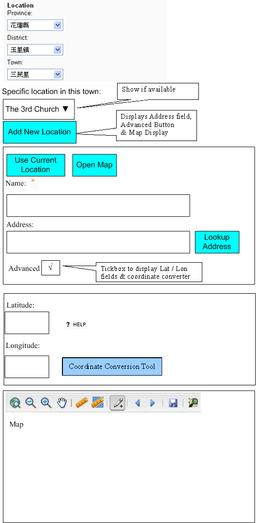
Location Selector
We want a widget which can be embedded within a form to be able to select the appropriate location to associate with a record using either hierarchical dropdowns or a precise location.
Status
We have a widget in views/gis/location_autocomplete.js
- this is added manually to many view templates (often this is the only customisation for that view)
This supports:
- Hierarchical Level selector to choose the correct level or select the correct Parent
- The country selector remains hidden if there is only 1 country being used (as per deployment_settings).
- The number of levels available depends on the deployment_settings.
- Initially just a single dropdown is displayed.
- When this dropdown is selected then the next dropdown is displayed, along with appropriate values
- We download the values via AJAX in order to not have to download all Locations
- The user has the option of adding a more specific Name & a Street Address
- This is not mandatory as some records need to link directly to the L0-L4 levels.
- Geocoder lookup of a Street Address
- Map-based lookup of Lat/Lon
- Manual entry of of Lat/Lon (either from a GPS or looked up in an online resource like Wikipedia)
- A Conversion tool is available to convert from Deg/Min/Sec to Decimal Degrees
ToDo
- Redesign the Look/Feel to make it more usable
- Display all the Lx layer dropdowns from the start?
- Hide the 'Add New Location' options behind a button (CSS Hide)
- Hide the Lat/Lon entry forms behind an 'Advanced' button (CSS Hide)
- Don't load the Map within the page but do this as a separate server-side call
- Make it work with components (see below)
- Move the implementation to a server-side widget so that it applies automatically to all instances of the field (can then remove from custom view templates)
- Add an HTML5 GeoLocation option ('Current Location')
- we should use a 'nearby' algorithm (like gis.get_features_in_radius()) to re-use existing locations rather than adding a new one each time.
- e.g. pr/person/presence could be recorded automatically upon login
- Set the map entry default lat/lon/zoom based on the selected Level in the Hierarchy (assumes we have at least Centroid information available, ideally use Polygons where we have them)
- Display the geocoder results on a map for visual confirmation that the correct result has been returned
- If we have admin boundaries available then the Lat/Lon provided can be validated against the selected Lat/Lon
- If we have admin boundaries available then the correct hierarchy can be filled-in automatically if just the Lat/Lon are provided
Known Issues
There are various bugs in the current implementation, some of which are listed below.
Duplication of location records
This happens when you for example create a new hospital record without creating a new location, but just selecting one (just select a country, for example). When you submit, then a new location record is created with the same name as the selected one - this seems wrong. You can make it visible by uncommenting the show_status line. The reason for this behaviour is that S3.gis.uuid is empty in case there is no old_location, which triggers the creation of a new record. Thus, this does not happen in update, and not either when you create a new location (which creates a new location anyway :D).
Use in Component Forms
To be able to apply the location selector to components (e.g. person/presence, where it would be *very* useful), we need to go away from the 'request.controller+"_"+request_function' construction and instead use jr.
Perhaps this way:
 {{try:}}
   var location_id = '{{=jr.prefix+"_"+jr.target()[1]+ "_location_id"}}';
 {{except:}}
   var location_id = '{{=request.controller+"_"+request.function+ "_location_id"}}';
 {{pass}}
PakistanDevelopers#LocationsSelector
Attachments (2)
- LocationSelector Wireframe.gif (27.3 KB ) - added by 15 years ago.
- LocationSelector Wireframe.vsd (113.0 KB ) - added by 15 years ago.
Download all attachments as: .zip
